This post may contain affiliate links where we earn from qualifying purchases. As an amazon associate, we earn from qualifying purchases. Find out more in our disclosure.
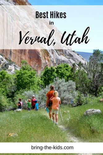
Eastern Utah may be one of the best hidden gems in the state of Utah when it comes to outdoor recreation. If you’re heading out to Vernal, here are the top hikes that you won’t want to miss.
Best hikes in and around Vernal Utah
Vernal has tons of different hikes, all within about an hours drive. The variety of hikes in Vernal is fantastic and here you’ll find hikes in the desert, mountains, and even along rivers.
TIP: The weather can get incredibly hot in Vernal during the summer so make sure to take a water bottle or hydration pack full of water to avoid getting dehydrated. We also recommend hiking in sturdy hiking shoes or hiking sandals so that you can hike longer and more comfortably.
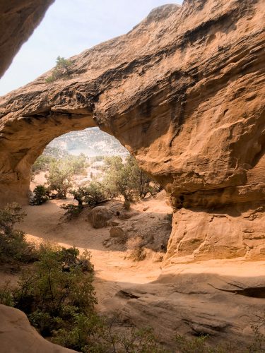
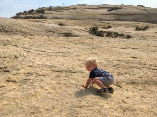
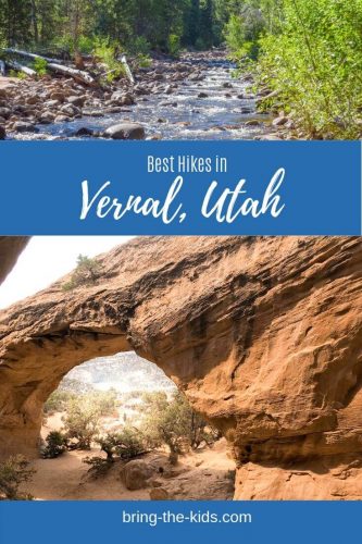
Moonshine Arch
Easy – 2 miles roundtrip
Moonshine Arch is the perfect desert hike that ends in some great slickrock and a huge arch.
Heading north out of Vernal on Highway 191, travel for about 6.5 miles until you reach mile marker #359, which is less than a mile past the entrance to Steinaker State Park. Turn left onto a small dirt road. After about ½ miles you will cross a small wash, and from here you want to stay to the left and follow the signs to Moonshine Arch. Park at the green gates further down the road with a cattle guard at them. From there, the trail looks like a small dirt road/ATV trail (not advised for cars, so just park and start hiking). From the parking lot the trail forks, so make sure to take the trail headed left and down into the wash. From there, the trail will fork two other times and you want to take the right fork at each. The majority of the trail is very sandy and flat with a few short steeper sections. It’s difficult to see Moonshine Arch until you are almost right on top of it.
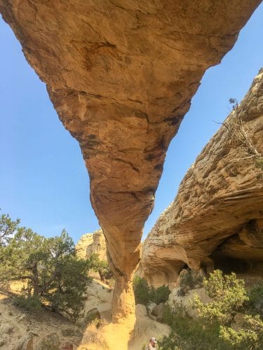
Once you get to the arch, there is lots of slickrock to climb around on and explore (both under the arch, as well as on the hill east of the arch. A few brave hikers that we saw were walking on the top of the arch without much trouble, though I wouldn’t recommend it for kids.
This trail has very little shade, so it is best to hike it during the morning or evening or on a cloudy day. Also because it can get VERY hot in the desert, make sure to take plenty of water with you.
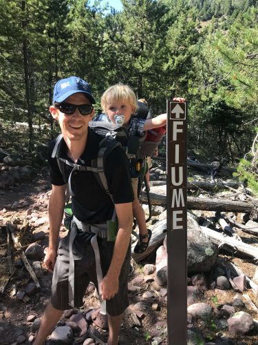
Dry Fork Flume Interpretive Trail
Moderate – 2 Miles One Way
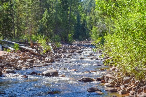
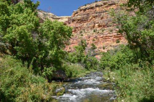
The Dry Fork Flume trail is very unique because while many of the other hikes around Vernal will have you feeling like you’re right in the desert, the Dry Fork Flume trail has more of a high alpine mountain feel to it. It provides great shade all throughout the day, and since many sections of it are along the Dry Fork Creek, it is much cooler than the surrounding areas.
To reach this trail, head north out of Vernal on 3500 West. The road leaves town and curves to the west past McConkie Ranch (make sure to stop and see the petroglyphs here). About 1.5 miles past McConkie Ranch, the road splits and you should take the right turn onto Dry Fork Settlement Road. Less than one mile past that, to stay on Dry Fork Settlement Road you must turn left.
The first parking lot is about 1.6 miles past this final turn and will have signs for the Dry Fork Interpretive Trail. From there you can hike 2 miles up to the next parking lot, and do a shuttle or make it a 4 mile trip and hike back. The first 2 miles has occasional signs along it so you can learn about the area, and is rated moderate because of some parts of the terrain. This section has many up and down sections that can be steep with some loose dirt as well, so watch your footing. From mile 2 until 4.5, the trail is more level and should be considered an easy hike. This trail is primarily in the shade, with a variety of trees along it, making it a great hike even during the middle of the day. In many sections of it, there are good views of the river below (seasonally). If you are interested in making the hike even longer, you can continue up another 2.5 miles to The Flume trailhead parking lot.
This trail is shared with mountain bikers, so please be courteous of other users. If you want more information on mountain biking this trail, read our full description here.
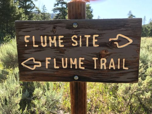
Dry Fork Flume Site Trail
EASY – 2.4 miles roundtrip
To really appreciate what Dry Fork Canyon is all about, you really need to take a hike up to the Flume Site. In the late 1800’s there was a settlement in Dry Fork, who were perplexed about the water situation there. For 9 months of the year, the creek appeared to by dry but in the spring, there was plenty of water. This happens because there are several underground sinks that collect the water, but to the settlers, they thought their water was just lost underground.
 In 1897, a flume was completed that would take water from the creek, before the sinks and transport it down to the farms and settlements below. Sadly, the flume leaked so much that it caused the water underneath it to be washed away and the flume was only operational for a short time. Today, you can hike along the dry creek bed and see the remains of the towers that once held the flume.
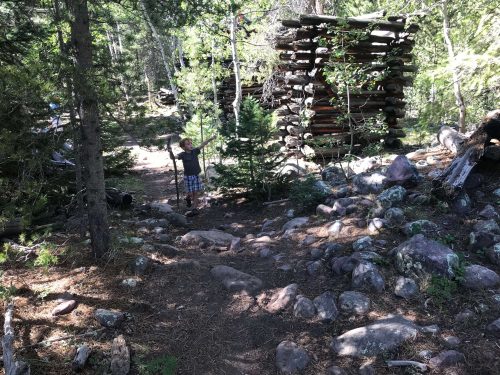
To get to the hike, go to The Flume trail head, 6.1 miles from the turnoff into Dry Fork Canyon, and turn left. From that road, continue on until you reach Massey Meadow. At Massey Meadow there is dispersed camping available as well as a pit toilet and a nature trail on the south side of the road. The road turns left at Massey Meadow and low clearance vehicles should use caution in this section since there are several rocks in the road as you drive up the hill. About ½ mile from Massey Meadow, there is a parking lot off to the left where the trail begins. The trail is quite obvious as you have to cross the bridge from the parking lot, and from there, make sure that you are heading west. It takes about 1.2 miles to reach the flume site, and it’s well worth the time to continue on down to the creek.
The creek is fairly shallow and slow moving there so it’s a great spot for a picnic or to let kids play in the water. The trail has shade on a few sections though you will also find yourself in direct sunlight a lot as well. Most of the trail is very flat.
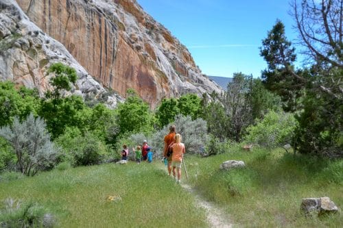
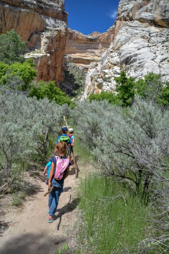
Jones Hole Trail
Easy – 8 miles Roundtrip
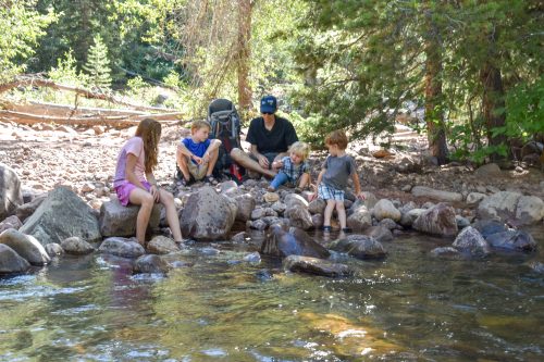
Jones Hole feels like it’s out in the middle of nowhere, but it’s absolutely worth the trek. At a little over an hour from Vernal, or about 3 days of river rafting to access it, it really is a gem that’s worth going the distance for. This is the perfect red rock canyon hike, in my opinion because about half of the trail is shaded with trees and it follows Jones Hole Creek the entire way so if you ever find yourself getting too hot, jump in and cool down!
Most hikers to the Jones Hole trail will start at the Jones Hole National Fish Hatchery. If you start there, plan on going in for a visit, as the rangers there will teach you all sorts of interetesting facts about the fish. Also, if you’ve got kids going with you, make sure to check out one of their free adventure packs for the day that are full of ________________________________
The first ½ mile of the hike can be pretty wet and muddy, depending on the time of year that you go. I recommend hiking in good hiking sandals, since you can easily wash them off in the river (and then it makes it so much easier to jump in and cool off too). My husband and I are both obsessed with these sandals here and here, and if you want to know our top recommendations for hiking sandals for kids, make sure to check out our kids sandal guide.
This first ½ mile of the hike is also where you’re the most likely to run into mosquitoes, so make sure you take a good bug spray like this one.
The following 1.5 miles will find you in the bottom of a giant canyon with towering red rock walls above you, which is a stunning site. At about mile 2, you’ll cross a bridge to the other side of the river (which is an excellent spot for splashing and swimming!). Just past the bridge, you’ll see a small trail that takes off to the right, towards the cliff that is about 100 feet away. Make sure to go on that side trail and hike along the cliff base for a while. You’ll get to see some great Freemont pictographs. This trail shortly meets up again with the main trail.
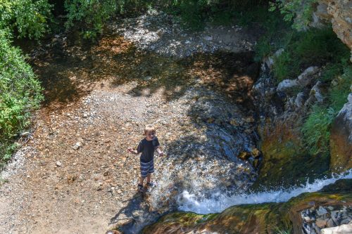
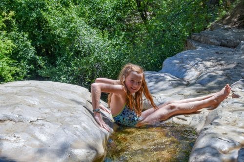
About .5 miles from the bridge, there is a side canyon on the right which will take you to Ely falls. This is a must visit and is only about .3 miles off the main trail! There are great places to cool off both at the top and bottom of the waterfall, making it a great place to cool off and relax a bit.
Fun fact: If you sit in the stream above the top of the waterfall, you can actually dam the entire waterfall up and stop it from flowing for a bit!
If you’re hiking with kids, Ely falls is a great place to turn around, which will make your total hike just over 5.5 miles. If you’ve got more time or energy, head back to the main trail and continue down to the Green River. It’s about two miles further and is very similar to the other sections of the hike. As you keep hiking, you’ll notice lots of river runners coming from their rafts to do this hike, but starting from the river! To access the Jones Hole Trail via the Green River, it takes about 3 days of floating through the Gates of Lodore section, to get to the trailhead. (This is one of our all time favorite river trips – read all about our trip there last summer with our kids!)
Josie’s Cabin Hikes, Dinosaur National Monument
Hog Canyon and Box Canyon Trails
EASY – 2 miles Roundtrip
Josie’s cabin is a historic cabin inside Dinosaur National Monument. Josie’s cabin is situated within a big grove of trees and there are several picnic tables around making it a perfect place for a snack or lunch.
Josie Morris was everything you would imagine when you think of a woman who lived in the wild west. She spend her childhood running wild through nature, and in her adult years, worked right alongside the men on the cattle ranch. At the cabin, you’ll see the home that Josie build with her own two hands and learn some of her stories like how she used to brew apricot brandy during prohibition and was once tried for cattle rustling when she was in her 60’s.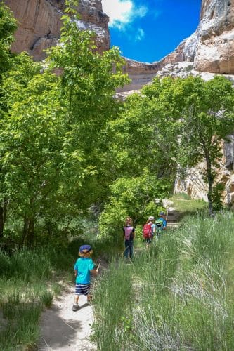
From Josie’s cabin, there are two small and simple hikes that you can do, though I’d recommend just doing both of them. Both Box Canyon and Hog Canyon were used by Josie as natural corals for her animals since they were blocked in on three sides by the canyon walls.
Box Canyon is a short flat hike that’s only ½ miles roundtrip. It takes you on a smooth trail back into a large and impressive box canyon (hence the name).
Hog Canyon is slightly longer at 1 ½ miles roundtrip, but is also pretty flat and a well maintained trail. The trail up Hog Canyon will take you past the pond that Josie built as well as her old chicken coop. There is plenty of shade along the trail and you’ll be treated to some excellent views as well.
Fantasy Canyon
EASY ½ mile
Fantasy Canyon feels completely otherworldly. A conglomeration of strangely shaped rock formations all seemingly smashed together to form a playground of sorts for outdoor lovers. The entire area isn’t incredibly large and you can easily walk through it all in about 30 minutes. To call it a hike might be a bit of a stretch, but it certainly is a great place to get off the beaten path for a bit and explore! Our kids had a wonderful time playing hide and seek among the rocks as well as racing down the different canyons.
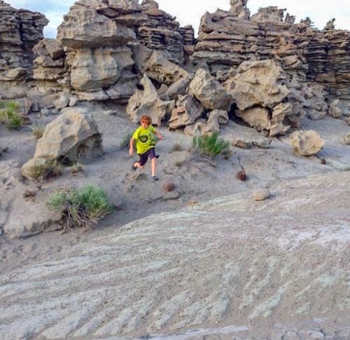
Please remember to be careful among the rocks, as they are delicate. You will notice that there are several well established trails, so please stick to those to help preserve this natural area.
To get to Fantasy Canyon, head south on Highway 45 for 24 miles. Turn right onto Glen Beach Road and go southwest for 13 miles. Turn left and then travel 4.4 miles further to Fantasy Canyon.
Want to learn about all of the best adventures in Eastern Utah? We’ve written everything you need to know HERE.
This article was made in collaboration with:

![]()
